New York: Béda antara owahan
Tanpa ringkesan besutan |
Tanpa ringkesan besutan |
||
| Larik 27: | Larik 27: | ||
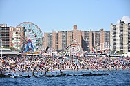
| alt8 = Crowded Coney Island beach with ferris wheel and roller coaster in background |
| alt8 = Crowded Coney Island beach with ferris wheel and roller coaster in background |
||
}} |
}} |
||
| image_caption = |
| image_caption = Saka ndhuwur, kiwa manengen: [[Lower Manhattan]] skyline, [[Central Park]], the [[Unisphere]], the [[Brooklyn Bridge]], [[Times Square]], the [[Statue of Liberty]], the [[United Nations headquarters]], and the [[Coney Island boardwalk|Boardwalk]] at [[Coney Island]] |
||
| image_flag = Flag of New York City.svg |
| image_flag = Flag of New York City.svg |
||
| image_seal = Seal_of_New_York_City_BW.svg |
| image_seal = Seal_of_New_York_City_BW.svg |
||
| Larik 64: | Larik 64: | ||
| government_type = [[Mayor–council government|Mayor–Council]] |
| government_type = [[Mayor–council government|Mayor–Council]] |
||
| governing_body = [[New York City Council]] |
| governing_body = [[New York City Council]] |
||
| leader_title = [[Mayor of New York City| |
| leader_title = [[Mayor of New York City|Walikutha]] |
||
| leader_name = [[Bill de Blasio]] ([[Democratic Party (United States)|D]]) |
| leader_name = [[Bill de Blasio]] ([[Democratic Party (United States)|D]]) |
||
| total_type = Total |
| total_type = Total |
||
| Larik 100: | Larik 100: | ||
| postal_code = 100xx–104xx, 11004–05, 111xx–114xx, 116xx |
| postal_code = 100xx–104xx, 11004–05, 111xx–114xx, 116xx |
||
| area_code = [[Area codes 212, 646, and 332|212/646/332]], [[Area codes 718, 347, and 929|718/347/929]], [[Area code 917|917]] |
| area_code = [[Area codes 212, 646, and 332|212/646/332]], [[Area codes 718, 347, and 929|718/347/929]], [[Area code 917|917]] |
||
| blank_name = [[Federal Information Processing Standards|FIPS code]] |
|||
| blank_info = 36-51000 |
|||
| blank1_name = [[Geographic Names Information System|GNIS]] feature ID |
|||
| blank1_info = 975772 |
|||
| blank2_name = Major airports |
|||
| blank2_info = [[John F. Kennedy International Airport|JFK Airport]]<br>[[Newark Liberty International Airport|Newark Liberty Airport]]<br>[[LaGuardia Airport]]<br>[[Islip Airport]]<br>[[White Plains Airport]]<br>[[Stewart International Airport|Stewart Airport]] |
|||
| blank4_name = [[Commuter rail]] |
|||
| blank4_info = [[LIRR]], [[Metro-North]], [[NJ Transit Rail Operations|NJ Transit]] |
|||
| blank5_name = [[Rapid transit]] |
|||
| blank5_info = [[File:MTA New York City Subway logo.svg|150px|link=New York City Subway]] |
|||
[[File:NYCS-bull-trans-SIR-Std.svg|35px|link=Staten Island Railway]] [[File:PATH.svg|40px|link=PATH (rail system)]] |
|||
| blank_name_sec2 = Largest [[Boroughs of New York City|borough]] by area |
|||
| blank_info_sec2 = [[Queens]] ({{convert|109|sqmi|km2|disp=or}}) |
|||
| blank1_name_sec2 = Largest borough by population |
|||
| blank1_info_sec2 = [[Brooklyn]] (2019 est. 2,559,903)<ref name="BrooklynQuickFacts">{{Cite web |title=State & County QuickFacts—Kings County (Brooklyn Borough), New York |url=http://quickfacts.census.gov/qfd/states/36/36047.html |archive-url=https://web.archive.org/web/20160217175357/http://quickfacts.census.gov/qfd/states/36/36047.html |archive-date=February 17, 2016 |access-date=May 16, 2020 |publisher=United States Census Bureau}}</ref> |
|||
| blank2_name_sec2 = Largest borough by [[GDP]] (2019) |
|||
| blank2_info_sec2 = [[Manhattan]] ($635.3 billion)<ref name="bea.gov" /> |
|||
| website = {{URL|https://www.nyc.gov/}} |
|||
| population_density_km2 = 10716.36 |
|||
|area_total_km2 = 1212.60 |
|||
|area_land_km2 = 777.95 |
|||
|area_water_km2 = 434.65 |
|||
}}'''New York City''' (kanthi resmi jenengé '''City of New York''') ya iku kutha gedhé dhéwé ing [[Amérika Sarékat]] lan salah sawijiné kutha kang paling wigati ing donya, mligi ing babagan kauangan donya lan komunikasi. Cacahé sing ndunungi ngluwihi 8 yuta jiwa sajeroning wewengkon sing ambané 800 [[km²]], lan populasi imigran kang akèh banget saka 180 nagara. |
}}'''New York City''' (kanthi resmi jenengé '''City of New York''') ya iku kutha gedhé dhéwé ing [[Amérika Sarékat]] lan salah sawijiné kutha kang paling wigati ing donya, mligi ing babagan kauangan donya lan komunikasi. Cacahé sing ndunungi ngluwihi 8 yuta jiwa sajeroning wewengkon sing ambané 800 [[km²]], lan populasi imigran kang akèh banget saka 180 nagara. |
||
Révisi kala 30 Juni 2021 14.56
| New York | |||||
|---|---|---|---|---|---|
| Kutha | |||||
Saka ndhuwur, kiwa manengen: Lower Manhattan skyline, Central Park, the Unisphere, the Brooklyn Bridge, Times Square, the Statue of Liberty, the United Nations headquarters, and the Boardwalk at Coney Island | |||||
| |||||
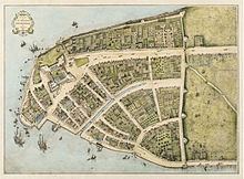
 Interactive map outlining New York City | |||||
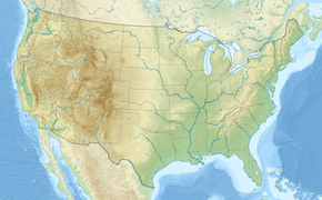
| Location within the state of New York##Location within the United States##Location within North America | |||||
| Koordhinat: 40°42′46″N 74°00′22″W / 40.71278°N 74.00611°WKoordhinat: 40°42′46″N 74°00′22″W / 40.71278°N 74.00611°W[1] | |||||
| Nagara | |||||
| Praja | |||||
| Region | Mid-Atlantic | ||||
| Constituent counties (boroughs) | Bronx (The Bronx) Kings (Brooklyn) New York (Manhattan) Queens (Queens) Richmond (Staten Island) | ||||
| Historic colonies | New Netherland Province of New York | ||||
| Settled | 1624 | ||||
| Consolidated | 1898 | ||||
| Named for | James, Duke of York | ||||
| Pamaréntahan | |||||
| • Jinis | Mayor–Council | ||||
| • Body | New York City Council | ||||
| • Walikutha | Bill de Blasio (D) | ||||
| Laladan[2] | |||||
| • Total | 468,19 sq mi (121,260 km2) | ||||
| • Land | 300,37 sq mi (77,800 km2) | ||||
| • Water | 167,82 sq mi (43,470 km2) | ||||
| • Métro | 13.318 sq mi (34,490 km2) | ||||
| Élepasi[3] | 33 ft (10 m) | ||||
| Cacah warga (2010)[6] | |||||
| • Total | 8.175.133 | ||||
| • Estimate (2019)[7] | 8.336.817 | ||||
| • Urut pepadhet | 1st in the U.S. | ||||
| • Pepadhet | 27.755,25/sq mi (1,071,636/km2) | ||||
| • MSA (2018) | 19,979,477[4] (1st) | ||||
| • CSA (2018) | 22,679,948[5] (1st) | ||||
| Demonym(s) | New Yorker | ||||
| Zona wektu | EST (UTC−05:00) | ||||
| • Usum panas (DST) | EDT (UTC−04:00) | ||||
| ZIP Codes | 100xx–104xx, 11004–05, 111xx–114xx, 116xx | ||||
| Kodhe laladan | 212/646/332, 718/347/929, 917 | ||||
| GDP (City, 2019) | $884 billion[8] (1st) | ||||
| GMP (Metro, 2020) | $1.67 trillion[9] (1st) | ||||
New York City (kanthi resmi jenengé City of New York) ya iku kutha gedhé dhéwé ing Amérika Sarékat lan salah sawijiné kutha kang paling wigati ing donya, mligi ing babagan kauangan donya lan komunikasi. Cacahé sing ndunungi ngluwihi 8 yuta jiwa sajeroning wewengkon sing ambané 800 km², lan populasi imigran kang akèh banget saka 180 nagara.
New York City uga dadi kutha krajan praja AS, New York. Kutha iki minangka mesin raksasa ékonomi donya, kanthi prodhuk metropolitan bruto sing gedhéné US$488,8 miliar ing taun 2003, gedhé dhéwé tinimbang kutha kutha ing AS lan nomer enem dibandingaké karo praja-praja AS liyané. Saupama dadi sawijiné nagara, New York City bakal duwé prodhuk dhomèstik bruto gedhé dhéwé angka 16 ing donya, ngluwihi Ruslan ($433 miliar). Bebarengan karo London, Paris, lan Tokyo, kutha iki dianggep salah siji saka papat kutha global ing donya. PBB uga nduwé markasé ing kutha iki wiwit taun 1951.
Kutha iki dijuluki "The Big Apple" ("Apel Gedhé"), "Kutha kang ora naté turu", utawa "Kutha krajan Donya". New York City misuwur amarga budayané, kemanekawarnané, gaya hidupé kang rikat, kosmopolitanisme, lan kesempatan ékonominé. Kutha iki, wektu iki uga kaloka amarga duwé tingkat kadurjanan paling endhèk dibandhingaké kutha kutha ing Amérika Sarékat liyané.[10]
Foto


Dhémografi
| Kutha New York Cacahing sing ndunungi miturut taun [2] | |
|---|---|
| 1790 | 33.131 |
| 1900 | 3.437.202 |
| 1950 | 7.891.957 |
| 1970 | 7.894.862 |
| 1980 | 7.071.639 |
| 1990 | 7.322.564 |
| 2004 | 8.168.338 |
Kutha Kembar
 Amsterdam, Walanda
 Beijing, Tiongkok
 Budapest, Honggari
 Kairo, Mesir
 Yerusalem, Israèl
 Johannesburg, Afrika Selatan
 Limerick, Irlandia
 London, Inggris
 Madrid, Spanyol
 Roma, Italia
 Santo Domingo, Républik Dominika
 Sydney, Australia
 Toronto, Kanadha
 Tokyo, Jepang
 Tegernsee, Jerman
Hubungan persahabatan karo:
Wacan Lanjutan
- National Geographic Traveler's Guide to New York City
- Edwin G. Burrows dan Mike Wallace (1998), Gotham: A History of New York City to 1898, Oxford University Press.
- Anthony Burgess (1976). New York, Little, Brown & Co.
- Federal Writers Project (1939). The WPA Guide to New York City, The New Press (terbitan ulang taun 1995).
- Kenneth T. Jackson (ed.) (1995). The Encyclopedia of New York City, Yale University Press.
- Kenneth T. Jackson dan David S. Dunbar (ed.) (2005), Empire City: New York Through the Centuries, Columbia University Press.
- E. B. White (1949). Here is New York, Little Bookroom (terbitan ulang taun 2000).
- Colson Whitehead (2003). The Colossus of New York: A City in 13 Parts, Doubleday.
- E. Porter Belden (1849). New York, Past, Present, and Future: Comprising a History of the City of New York, a Description of its Present Condition, and an Estimate of its Future Increase, New York, G.P. Putnam. dari Google Books
Cathetan
- ↑ "US Gazetteer files: 2010, 2000, and 1990". United States Census Bureau. February 12, 2011. Dibukak ing April 23, 2011.
- ↑ "2019 U.S. Gazetteer Files". United States Census Bureau. Dibukak ing July 27, 2020.
- ↑ "US Board on Geographic Names". United States Geological Survey. June 23, 2018. Dibukak ing January 31, 2008. Search for feature ID 975772.
- ↑ "Annual Estimates of the Resident Population: April 1, 2010 to July 1, 2017—Metropolitan Statistical Area; and for Puerto Rico—2017 Population Estimates". U.S. Census Bureau. Diarsip saka sing asli ing February 13, 2020. Dibukak ing March 24, 2018.
- ↑ "Annual Estimates of the Resident Population: April 1, 2010 to July 1, 2018—Combined Statistical Area; and for Puerto Rico—2017 Population Estimates". U.S. Census Bureau. Dibukak ing April 27, 2018.
- ↑ Community Facts for New York City, United States Census Bureau. Retrieved May 26, 2017.
- ↑ "Population and Housing Unit Estimates". Dibukak ing May 21, 2020.
- ↑ Gross Domestic Product by County, 2019, Bureau of Economic Analysis, released December 9, 2020. Accessed December 9, 2020.
- ↑ "U.S. metro areas—ranked by Gross Metropolitan Product (GMP) 2020 | Statistic". Statista. Dibukak ing May 31, 2019.
- ↑ "NYC Is Safest City as Crime Rises in U.S., FBI Say." Bloomberg News 12 Juni 2006.[1]
Pranala njaba
| Wikimedia Commons duwé médhia ngenani New York City. |
| Wikiplesir duwé panuntun plesir ngenani New York City. |
| Artikel iki minangka artikel rintisan. Kowé bisa ngéwangi Wikipédia ngembangaké. |


