
Barkas:Eyjafjallajökull volcanic ash 17 April 2010.png
Ora ana résolusi kang luwih dhuwur.
Eyjafjallajökull_volcanic_ash_17_April_2010.png (680 × 520 piksel, ukuran barkas: 127 KB, jinis MIME: image/png)
| Panyandra |
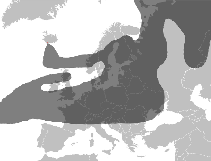
Approximate drawing of estimated ash cloud from the Eyjafjallajökull eruption as of 17 April 2010 at 18:00 UTC. Source: http://www.metoffice.gov.uk/aviation/vaac/data/VAG_1271527299.png Newer map: File:Eyjafjallajökull volcanic ash 19 April 2010.png Updates at http://www.metoffice.gov.uk/aviation/vaac/vaacuk_vag.html |
| Tanggal | (UTC) |
| Sumber | |
| Juru pangarang |
|
| Ini merupakan gambar hasil penyuntingan yang berarti bahwa gambar tersebut telah diubah secara digital dari versi asli. Perubahan: drawed ash coverage. Versi asli dapat dilihat di sini: Blank map of Europe.svg:
|
Barkas iki kalilakaké sangisoring palilah Creative Commons Atribusi-Andum Mèmper 3.0 Tanpa Adhaptasi.
- Kowé kena:
- ngedum – nyalin, nyebar, lan ngirim karya
- nyampur – ngolah karya
- Sangisoré kahanan mangkéné:
- atribusi – Kowé kudu mènèhi krédhit kang patut, mènèhi pranala lisènsi, lan kandha yèn ana owah-owahan. Kowé bisa tumindak sasenengmu, nanging ora teges kang duwé lisènsi njurung lakumu.
- andum mèmper – Manawa kowé nyalin rupa, ngowahi, utawa nggawé karya nganggo bahan karya iki, kowé kudu mbabar karyamu kang wis dadi nganggo lisènsi kang padha utawa kang cocog karo karya asliné..
Log unggah asli
This image is a derivative work of the following images:
- File:Blank_map_of_Europe.svg licensed with Cc-by-sa-2.5
- 2008-09-17T09:50:25Z F7 680x520 (531491 Bytes)
- 2008-09-17T09:42:57Z F7 680x520 (2353 Bytes)
- 2008-05-26T19:04:07Z Collard 680x520 (531491 Bytes) uploading on behalf of [[User:Checkit]], direct complaints to him plox: 'Moved countries out of the "outlines" group, removed "outlines" style class, remove separate style information for Russia'
- 2008-04-30T01:38:52Z TimothyBourke 680x520 (531767 Bytes) Changed the country code of Serbia to RS per [http://en.wikipedia.org/wiki/Serbian_country_codes] and the file [http://www.iso.org/iso/iso3166_en_code_lists.txt].
- 2008-02-08T22:44:37Z CarolSpears 680x520 (531767 Bytes) validated
- 2007-07-10T11:47:59Z MrWeeble 680x520 (533112 Bytes) Updated to include British Crown Dependencies as seperate entities and regroup them as "British Islands", with some simplifications to the XML and CSS
- 2007-05-14T17:17:34Z Zirland 680x520 (540659 Bytes) serbia and montenegro
- 2007-03-30T20:40:49Z W!B: 680x520 (538830 Bytes) minor corr: update nl:Ijsselmeer, del fi:lakes (all small), add ru:lake Oneka (all ref maps.google), glued northern irland back to ie ;)
- 2007-02-05T18:44:32Z Maix 680x520 (538295 Bytes) cropped
- 2007-02-04T15:07:29Z Maix 680x520 (538310 Bytes) {{Information |Description=A blank Map of Europe in SVG format. Every country has an id which is its ISO-3116-1-ALPHA2 code in lower case for easy coloring. |Source=Image based on [[Image:Europe_countries.svg|]] by [[User:Ti
Uploaded with derivativeFX
Sajarahing berkas
Klik ing tanggal/wektuné saprelu ndeleng rupané barkasé nalika tanggal iku.
| Tanggal/Wektu | Gambar cilik | Alang ujur | Naraguna | Tanggepan | |
|---|---|---|---|---|---|
| saiki | 17 April 2010 21.24 | | 680 × 520 (127 KB) | Hydrox | Enhanced approximation of the same source. |
| 17 April 2010 20.01 |  | 680 × 520 (127 KB) | Hydrox | Updated to reflect the data as of April 17th, 18:00 UTC (http://www.metoffice.gov.uk/aviation/vaac/data/VAG_1271527299.png) | |
| 16 April 2010 16.43 |  | 680 × 520 (127 KB) | Cogiati | {{Information |Description=Approximate drawing of estimated ash cloud from the Eyjafjallajökull eruption as of 17 April 2010 at 06:00 UTC. Source: http://www.metoffice.gov.uk/aviation/vaac/data/VAG_1271417376.png Updates at http://www.metoffice.gov.uk/a |
Panggunaning berkas
Kaca ing ngisor iki nganggo barkas iki:
Panggunané barkas sajagat
Wiki liya ngisor iki nganggo barkas iki:
- Kanggo ing an.wikipedia.org
- Kanggo ing arz.wikipedia.org
- Kanggo ing ca.wikipedia.org
- Kanggo ing cs.wikipedia.org
- Kanggo ing da.wikipedia.org
- Kanggo ing de.wikipedia.org
- Kanggo ing de.wikinews.org
- Kanggo ing en.wikipedia.org
- Kanggo ing en.wikinews.org
- Kanggo ing eu.wikipedia.org
- Kanggo ing fi.wikipedia.org
- Kanggo ing fi.wikinews.org
- Kanggo ing he.wikipedia.org
- Kanggo ing hr.wikipedia.org
- Kanggo ing hu.wikipedia.org
- Kanggo ing hu.wikinews.org
- Kanggo ing id.wikipedia.org
- Kanggo ing incubator.wikimedia.org
- Kanggo ing it.wikipedia.org
- Kanggo ing ja.wikipedia.org
- Kanggo ing km.wikipedia.org
- Kanggo ing nl.wikipedia.org
- Kanggo ing no.wikipedia.org
- Kanggo ing pl.wikipedia.org
- Kanggo ing pl.wikinews.org
- Kanggo ing ru.wikipedia.org
- Kanggo ing sh.wikipedia.org
- Kanggo ing sr.wikipedia.org
- Kanggo ing sv.wikipedia.org
- Kanggo ing tr.wikinews.org
- Kanggo ing uk.wikipedia.org