
Barkas:Oder-Neisse line between Germany and Poland.jpg
Gedhéning pratuduh iki: 674 × 599 piksel Résolusi liya: 270 × 240 piksel | 540 × 480 piksel | 785 × 698 piksel.
Berkas asli (785 × 698 piksel, ukuran barkas: 102 KB, jinis MIME: image/jpeg)


Ringkesan
| Panyandra |
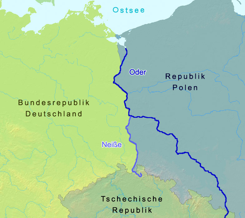
English: The named rivers are the border of Germany and Poland: the Oder-Neisse line, save at the north end it is shifted slightly west to include the Polish city Szczecin and Polish-speaking villages. The countries are named in German. Czechia in its national tongue is Česko. Poland, in its, is Polska. The Baltic Sea is, in Polish,
morze Bałtyckie.
Deutsch: Grenze zwischen Polen und Deutschland entlang der Oder-Neiße-Grenze |
| Tanggal | |
| Sumber | A map from demis.nl |
| Juru pangarang | Christoph Lingg |
| Idin (Nganggo manèh barkas iki) |
cc-by-sa-2.0-de |
| Uploaded at de.Wikipedia | 21 Maret 2006 12:55 |
| Uploaded at Commons | 15 Mèi 2006 15:18 (UTC) |
Lisènsi
Berkas ini dilisensikan di bawah lisensi Creative Commons Atribusi-Berbagi Serupa 2.0 Jerman.
- Kowé kena:
- ngedum – nyalin, nyebar, lan ngirim karya
- nyampur – ngolah karya
- Sangisoré kahanan mangkéné:
- atribusi – Kowé kudu mènèhi krédhit kang patut, mènèhi pranala lisènsi, lan kandha yèn ana owah-owahan. Kowé bisa tumindak sasenengmu, nanging ora teges kang duwé lisènsi njurung lakumu.
- andum mèmper – Manawa kowé nyalin rupa, ngowahi, utawa nggawé karya nganggo bahan karya iki, kowé kudu mbabar karyamu kang wis dadi nganggo lisènsi kang padha utawa kang cocog karo karya asliné..

Log unggah asli
Image history of de:Bild:Oder neisse grenze.jpg:
| Upload date | User | Bytes | Dimensions | Comment |
|---|---|---|---|---|
| 2006-03-21 17:57 | C.lingg | 104,398 | 785×698 | * Bildbeschreibung: Grenzverlauf zwischen Deutschland und Polen in Bezug auf die Oder-Neiße-Grenze * Quelle: Landkarte: demis.nl * Fotograf/Zeichner: Christoph Lingg * Datum: 22.03.2006 * Version: 2, Kontrast der Färbung von Dtl und Polen verstärkt |
| 2006-03-21 12:55 | C.lingg | 112,647 | 785×698 | * Bildbeschreibung: Grenzverlauf zwischen Deutschland und Polen in Bezug auf die Oder-Neiße-Grenze * Quelle: Landkarte: demis.nl * Fotograf/Zeichner: Christoph Lingg * Datum: 22.03.2006 |
Sajarahing berkas
Klik ing tanggal/wektuné saprelu ndeleng rupané barkasé nalika tanggal iku.
| Tanggal/Wektu | Gambar cilik | Alang ujur | Naraguna | Tanggepan | |
|---|---|---|---|---|---|
| saiki | 15 Juni 2006 15.19 | | 785 × 698 (102 KB) | Thuresson | more contrast |
| 15 Juni 2006 15.18 |  | 785 × 698 (110 KB) | Thuresson |
Panggunaning berkas
Kaca ing ngisor iki nganggo barkas iki:
Panggunané barkas sajagat
Wiki liya ngisor iki nganggo barkas iki:
- Kanggo ing ar.wikipedia.org
- Kanggo ing arz.wikipedia.org
- Kanggo ing azb.wikipedia.org
- Kanggo ing az.wikipedia.org
- Kanggo ing be.wikipedia.org
- Kanggo ing br.wikipedia.org
- Kanggo ing ca.wikipedia.org
- Kanggo ing cs.wikipedia.org
- Kanggo ing cy.wikipedia.org
- Kanggo ing da.wikipedia.org
- Kanggo ing de.wikipedia.org
- Kanggo ing dsb.wikipedia.org
- Kanggo ing el.wikipedia.org
- Kanggo ing en.wikipedia.org
- Kanggo ing eo.wikipedia.org
- Kanggo ing es.wikipedia.org
- Kanggo ing es.wikibooks.org
- Kanggo ing eu.wikipedia.org
- Kanggo ing fa.wikipedia.org
- Kanggo ing fi.wikipedia.org
- Kanggo ing fr.wikipedia.org
- Kanggo ing fy.wikipedia.org
- Kanggo ing ga.wikipedia.org
- Kanggo ing gl.wikipedia.org
Deleng naraguna liyané sadonya saka kaca iki.