Barkas:Breakup of Yugoslavia.gif
Konten halaman tidak didukung dalam bahasa lain.
Saka Wikipédia Jawa, bauwarna mardika basa Jawa

Berkas asli(1.545 × 1.242 piksel, ukuran barkas: 187 KB, jinis MIME: image/gif, mubeng, 14 rangka, 44 d)

Barkas iki saka Wikimedia Commons lan kena kanggo proyèk liya. Panyandraning kaca panyandra barkasé kapacak ing ngisor.

This image could be re-created using vector graphics as an SVG file. This has several advantages; see Commons:Media for cleanup for more information. If an SVG form of this image is available, please upload it and afterwards replace this template with {{vector version available|new image name}}. It is recommended to name the SVG file "Breakup of Yugoslavia.svg" - then the template Vector version available (or Vva) does not need the new image name parameter.

Ringkesan

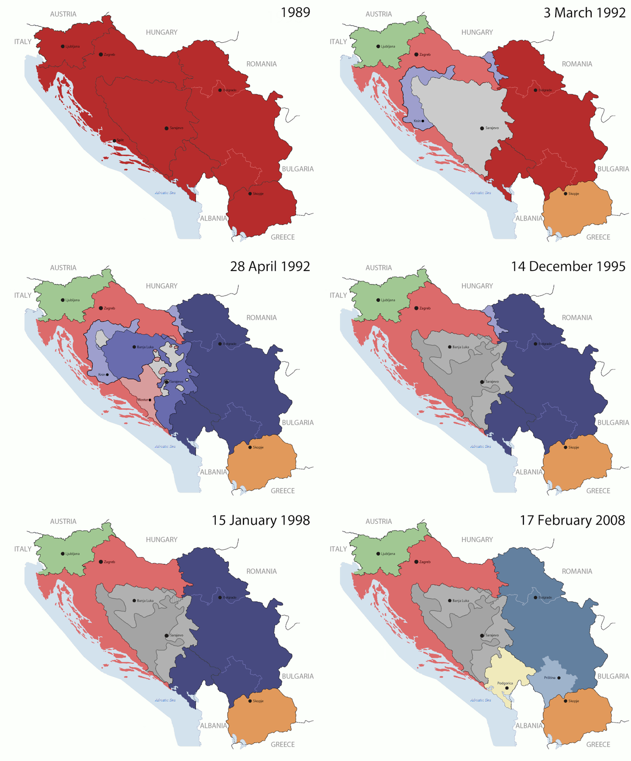
Key:

Yugoslavia (1943–1992) SFR Yugoslavia
Croatia (1991–present) Croatia
Herzeg-Bosnia (1992–1994)
UNTAES (1996–1998)
Federal Republic of Yugoslavia / Serbia and Montenegro (1992–2006) Serbia and Montenegro
Republika Srpska (1992–present) Republika Srpska
Serbian Krajina (1991–1995/96)
Republic of Bosnia and Herzegovina (1992–1995)
Bosnia and Herzegovina (1998–present) Bosnia and Herzegovina
Western Bosnia (1993–1995)
Serbia (2006–present) Serbia
Kosovo (under UNMIK control 1999–present; declaration of independence 2008) Kosovo
Montenegro (2006–present) Montenegro
Macedonia (1991–present) Macedonia
Slovenia (1991–present) Slovenia


Panyandra

This is an animated GIF that shows the stages of the breakup of the SFR Yugoslavia in the 90's and 2000's. The map based off Morwen's map of the divisions of the SFRY, Which is licensed by the GFDL. The source for the dates of independence is the CIA World Factbook. These maps do not now show the Inter-Entity Boundary Line (IEBL) and/or the entities that are separated by it. The IEBL has been drawn based on this CIA map; the Brčko District has been drawn based on Image:BH municipality location.gif, by user:Ante Perkovic. I might add them in the future.

Since the original map was GFDL, this image is as well.

A map depicting Kosovo's final status is ready once it takes effect.


Changelog for versions 2/3:

Here are some changes in this new build of the map:

  • The Kosovo boundary has been given a shade of red instead of the previous UN blue since they are a province of Serbia under UNIMIK control.
  • Montenegro's color has been changed to a golden shade close to what's on the flag.
  • The IEBL and the Brčko District has been redrawn because I deleted the original map; the color for the Republika Srpska is lighter.
  • The dates are at the top left hand corner of the map instead of the bottom.
  • I have taken a new approach as to the boundaries. Each part of Yugoslavia now shows the boundary on the maps starting the year they broke away. I feel this change helps readers understand the breakup better.
  • The SFRY and the FRY are in different shades since the FRY was never accepted as the successor to the former by the UN.
  • The colors for the entities of BiH have been removed as to not confuse people into thinking that they are independent states. What remains is the IEBL with both entities in green.
  • The Kosovo boundary is finally in hash marks!
  • The Brčko District has been removed. The sale is too small to show accurately.

Changelog for version 4:

  • The map is larger!
  • The image has been rebuilt to include the eastern part of FYR Macedonia.
  • The image has been updated to take in Kosovo's new status.
  • The IEBL is now a darker line.
  • Montenegro, Kosovo, and FRY/SCG/Serbia have new colors!

Changelog for version 5:

  • Rebuilt
  • Larger map: size of base image
  • Accurate Inter-Entity Boundary Line
Tanggal 24 July 2006 (orginal upload date)
Sumber Made by Hoshie; see above for more details on sources.
Juru pangarang Hoshie
Vèrsi liya

Lisènsi

GNU head Idih kawènèhaké saprelu nyalin, ngedum, lan/utawa ngowah layang iki manut bebaku Palilah Pilayang Bébas GNU, Angka 1.2 utawa angka luwih anyar sing dibabar Yeyasan Piranti Alus Bébas; tanpa Pérangan Invarian, tanpa Tulisan Samak Arep, lan tanpa Tulisan Samak Buri. Salinan palilah dirembug ing pérangan asesirah Palilah Pilayang Bébas GNU.
w:id:Creative Commons
atribusi andum mèmper
Barkas iki kalilakaké sangisoring palilah Creative Commons Atribusi-Andum Mèmper 3.0 Tanpa Adhaptasi.
Kowé kena:
  • ngedum – nyalin, nyebar, lan ngirim karya
  • nyampur – ngolah karya
Sangisoré kahanan mangkéné:
  • atribusi – Kowé kudu mènèhi krédhit kang patut, mènèhi pranala lisènsi, lan kandha yèn ana owah-owahan. Kowé bisa tumindak sasenengmu, nanging ora teges kang duwé lisènsi njurung lakumu.
  • andum mèmper – Manawa kowé nyalin rupa, ngowahi, utawa nggawé karya nganggo bahan karya iki, kowé kudu mbabar karyamu kang wis dadi nganggo lisènsi kang padha utawa kang cocog karo karya asliné..
Tag lisènsi iki ditambahaké nèng berkas iki minangka bagéyané panganyaran lisènsi GFDL.

Captions

Add a one-line explanation of what this file represents

Items portrayed in this file

gegambaran

status hak cipta Indonesia

berhak cipta Indonesia

tipe media Indonesia

image/gif

checksum Inggris

05ca2aefea8406b809968643552d5095c847a42f

metode penentuan Indonesia: SHA-1 Indonesia

ukuran data Indonesia

191.625 Bita

durasi Indonesia

44 detik

tinggi Indonesia

1.242 piksel

lebar Indonesia

1.545 piksel

Sajarahing berkas

Klik ing tanggal/wektuné saprelu ndeleng rupané barkasé nalika tanggal iku.

(anyar dhéwé | lawas dhéwé) Deleng (10 luwih anyar | ) (10 | 20 | 50 | 100 | 250 | 500)
Tanggal/WektuGambar cilikAlang ujurNaragunaTanggepan
saiki17 Juli 2016 07.40Gambar cilik kanggo owahan 17 Juli 2016 07.401.545 × 1.242 (187 KB)מפתח-רשימהReverted to version as of 17:22, 21 August 2015 (UTC)
21 Agustus 2015 17.22Gambar cilik kanggo owahan 21 Agustus 2015 17.221.463 × 1.158 (1,81 MB)BraganzaReverted to version as of 03:57, 19 January 2010
21 Agustus 2015 17.22Gambar cilik kanggo owahan 21 Agustus 2015 17.221.545 × 1.242 (187 KB)BraganzaReverted to version as of 01:02, 19 December 2011
21 Agustus 2015 17.15Gambar cilik kanggo owahan 21 Agustus 2015 17.15120 × 95 (3 KB)Braganza03:57, 19. Jan. 2010
19 Dhésèmber 2011 01.02Gambar cilik kanggo owahan 19 Dhésèmber 2011 01.021.545 × 1.242 (187 KB)DIREKTORAdded details
27 Juli 2011 18.09Gambar cilik kanggo owahan 27 Juli 2011 18.091.545 × 1.242 (170 KB)DIREKTORSmall fixes
27 Juli 2011 17.28Gambar cilik kanggo owahan 27 Juli 2011 17.281.545 × 1.242 (171 KB)DIREKTORAdded UNMIK
27 Juli 2011 16.38Gambar cilik kanggo owahan 27 Juli 2011 16.381.545 × 1.242 (165 KB)DIREKTORDates for the last two frames.
27 Juli 2011 12.10Gambar cilik kanggo owahan 27 Juli 2011 12.101.545 × 1.242 (149 KB)DIREKTORLighter shade for country names
26 Juli 2011 16.59Gambar cilik kanggo owahan 26 Juli 2011 16.591.545 × 1.242 (170 KB)DIREKTORHigher res plus details
(anyar dhéwé | lawas dhéwé) Deleng (10 luwih anyar | ) (10 | 20 | 50 | 100 | 250 | 500)

Ora ana kaca kang nganggo barkas iki.

Panggunané barkas sajagat

Wiki liya ngisor iki nganggo barkas iki:

Deleng naraguna liyané sadonya saka kaca iki.

Métadhatah