
Barkas:East-Hem 200ad.jpg

Berkas asli (3.240 × 1.903 piksel, ukuran barkas: 734 KB, jinis MIME: image/jpeg)


Ringkesan
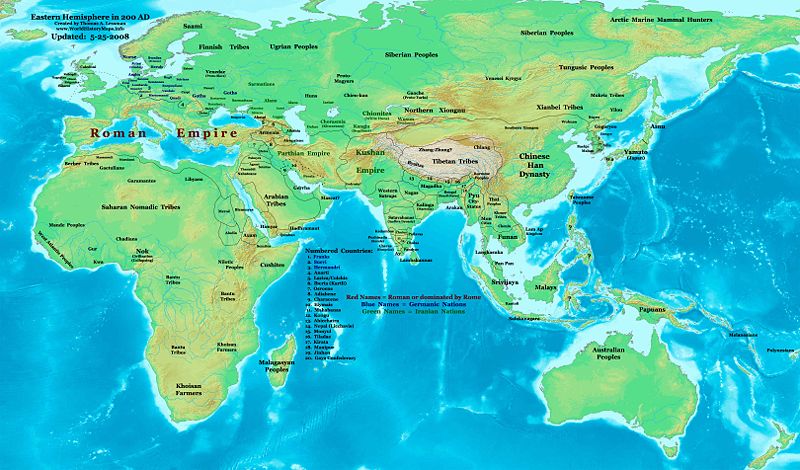
| Panyandra | Eastern Hemisphere in 200 AD. |
| Sumber | self-made (For reference information, see the Map Source References section below.) |
| Juru pangarang | Thomas Lessman (Contact!) |
| Idin (Nganggo manèh barkas iki) |
Kula, sing nduwèni hak cipta karya iki, mawa iki nerbitaké berkas iki sakisoré lisènsi kasebut: Barkas iki kalilakaké sangisoring palilah Creative Commons Atribusi-Andum Mèmper 3.0 Tanpa Adhaptasi.
|
| Vèrsi liya |
Karya turunan dari berkas ini: Part of East Hem 200 AD.jpg see East-Hem_200ad.jpg file history on Wikipedia. |
Map Summary
Original Source URL: http://www.thomaslessman.com/History/images/East-Hem_200ad.jpg.
This map of the Eastern Hemisphere in 200 AD was created by Thomas Lessman, based on information from the sources listed below. This map is free for educational use (see Permission info above). When using this map, please mention that it is available for free at www.WorldHistoryMaps.info.
Map Source References
- Remember, sources often conflict with each other. This map is only as accurate as the information that is available to me. To report any errors or to help further this work, please click here, or email Thomas Lessman at talessman@yis.us
References for information contained in this map:
Primary Sources:
- 1. The DK Atlas of World History, 2000 Edition; map of The World in 250 CE, (Pages 46-47).
- 2. History and Commercial Atlas of China; map of Asia in 200 AD; available on Huhai.net.
- 3. Countries of the World, 1-1-136 CE archive copy at the Wayback Machine map available on www.WorldHistoryMaps.com.
- 4. Map of the World in 200 CE, created by Wikimedia's User:Javierfv1212.
I - European Information is derived primarily from this Map of Europe in 200 AD from www.Euratlas.com.
II - Asian Information is derived primarily from:
- Han Dynasty borders are derived from the History and Commercial Atlas of China (see above, #2 under Primary Sources).
- Indian borders are derived from a combination of these sources:
- Wikimedia's map of the World in 200 CE, created by User:Javierfv1212.
- This map of the Countries of the World, 1-1-136 CE archive copy at the Wayback Machine, available on www.WorldHistoryMaps.com.
- Wikimedia's map of Western Kshatrapas (Western Satraps), created by User:PHG.
- Wikimedia's Satavahana Map, created by User:PHG.
- Korean borders derive from this map of Korea-204.png made by Wikipedia User:Historiographer.
- Kushan Empire borders are derived from a mix of the sources below:
- The DK Atlas of World History (see above, #1 under Primary Sources).
- History and Commercial Atlas of China (see above, #2 under Primary Sources).
- Parthian Empire borders derive from:
- History and Commercial Atlas of China (see above, #2 under Primary Sources).
- Wikimedia's map of the World in 200 CE (see above, #4 under Primary Sources).
- Roman borders in Asia, along with borders for states in Iraq and Caucasus Mts, are derived from the Map of Europe in 200 AD from www.Euratlas.com.
III - African Information, and fringe areas like Australia, Siberia, etc. derive from:
- Wikimedia's map of the World in 200 CE, created by User:Javierfv1212.
- The DK Atlas of World History, 2000 Edition; map of The development of complex societies in Africa; (Page 160).
Note: Much of the information in this map was cross-checked with Bruce Gordon's Regnal Chronologies.
Other Maps by Thomas Lessman
| Maps of the eastern hemisphere showing history
Bold dates are available on Wikimedia or Wikipedia. | ||
| Primeval | ||
| Ancient
|
·| 600 BC | 550 BC | 527 BC | 500 BC |
400 BC | ·| 1 AD | 50 AD | 100 AD | 200 AD | 300 AD | | |
| Medieval |
·| 500 AD | 565 AD | 600 AD | 700 AD | | |
| Modern |
·| 1500 AD | · * For historical maps of the whole world, | |
Other Info
Sajarahing berkas
Klik ing tanggal/wektuné saprelu ndeleng rupané barkasé nalika tanggal iku.
| Tanggal/Wektu | Gambar cilik | Alang ujur | Naraguna | Tanggepan | |
|---|---|---|---|---|---|
| saiki | 26 Mèi 2008 00.22 | | 3.240 × 1.903 (734 KB) | Talessman | Corrections to borders in West Asia, India, Southeast Asia, China, and Korea. Added more information based on new references. Other misc. corrections and updates. |
| 9 Mèi 2008 16.27 |  | 3.240 × 1.903 (720 KB) | Talessman | {{Information |Description=Eastern Hemisphere in 200 AD. |Source=self-made |Author=Thomas Lessman |Permission={{self|cc-by-sa-3.0}} }} |
Panggunaning berkas
Kaca ing ngisor iki nganggo barkas iki:
Panggunané barkas sajagat
Wiki liya ngisor iki nganggo barkas iki:
- Kanggo ing ar.wikipedia.org
- Kanggo ing be-tarask.wikipedia.org
- Kanggo ing bg.wikipedia.org
- Kanggo ing bn.wikipedia.org
- Kanggo ing bs.wikipedia.org
- Kanggo ing ca.wikipedia.org
- Kanggo ing cv.wikipedia.org
- Kanggo ing de.wikipedia.org
- Kanggo ing el.wikipedia.org
- Kanggo ing en.wikipedia.org
- 3rd century
- 200
- Proto-Mongols
- History of Eurasia
- Chutu dynasty
- Talk:Odia language
- User:Tompw/sandbox10
- User:Talessman/Maps
- User talk:Talessman/Maps
- Timeline of ancient history
- Comparative studies of the Roman and Han empires
- User:Benjamin Trovato/sandbox
- Nagas of Padmavati
- List of Classical Age states
- User:Joelton Ivson/Gather lists/24978 – Os Romanos
- User:Falcaorib
- Achyuta of Panchala
- Kanggo ing en.wikibooks.org
- Kanggo ing en.wikiversity.org
- Kanggo ing eo.wikipedia.org
- Kanggo ing es.wikipedia.org
- Kanggo ing fi.wikipedia.org
- Kanggo ing frr.wikipedia.org
- Kanggo ing gl.wikipedia.org
- Kanggo ing he.wikipedia.org
- Kanggo ing hy.wikipedia.org
- Kanggo ing id.wikipedia.org
- Kanggo ing it.wikipedia.org
- Kanggo ing ko.wikipedia.org
- Kanggo ing lv.wikipedia.org
- Kanggo ing mk.wikipedia.org
Deleng naraguna liyané sadonya saka kaca iki.