
Barkas:Snow-cholera-map.jpg

Berkas asli (889 × 869 piksel, ukuran barkas: 248 KB, jinis MIME: image/jpeg)
Ringkesan
| Deskripsi |
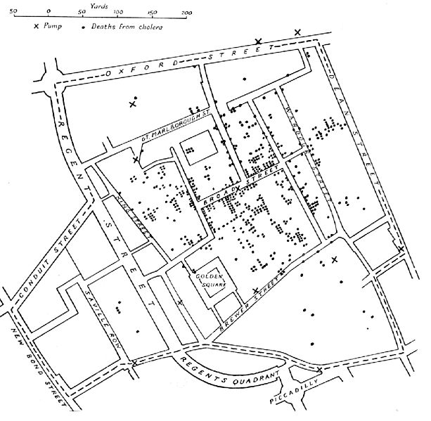
English: A variant of the original map drawn by Dr. John Snow (1813-1858), a British physician who is one of the founders of medical epidemiology, showing cases of cholera in the London epidemics of 1854, clustered around the locations of water pumps.
Español: Mapa original dibujado por el Dr. John Snow (1813-1858), médico inglés precursor de la epidemiología, que muestra los casos de cólera en la epidemia ocurrida en Londres en 1854. Los puntos muestran la localización de las personas afectadas por beber agua de los pozos (cruces)
Português: Mapa original elaborado pelo Dr. John Snow (1813-1858), médico britânico, um dos precursores da epidemiologia. O mapa mostra casos de cólera numa epidemia ocorrida em Londres em 1854. Os pontos indicam a localização de pessoas afetadas pela cólera por consumir água de poços, indicados pelas cruzes.
Nederlands: De originele kaart gemaakt door Dr. John Snow (1813-1858), een Engelse arts en een van de grondleggers van de medische epidemiologie, laat zien waar gevallen van cholera plaatsvonden tijdens de Londense epidemie van 1854, in relatie tot de waterpompen (kruisjes).
Deutsch: Variante einer im Original von Dr. John Snow (1813–1858) gezeichneten Karte. Der britische Arzt war ein Pionier der epidemiologischen Erforschung der Cholera. Die Karte zeigt Cholerafälle bei der Epidemie in London 1854, die sich bei einer Wasserpumpe (an der Broad Street) häufen. |
|||||||||
| Sumber |
Tak diketahui Transferred from en.wikipedia to Commons. |
|||||||||
| Pencipta |
after John Snow |
|||||||||
| Geotemporal data | ||||||||||
| Bounding box |
|
|||||||||
| Georeferencing | ||||||||||
| Vèrsi liya | File:Snow-cholera-map-1.jpg, the original | |||||||||
Lisènsi
|
This work is in the public domain in its country of origin and other countries and areas where the copyright term is the author's life plus 70 years or fewer.
| |
| Berkas ini telah diidentifikasi bebas dari pembatasan menurut hukum hak cipta termasuk semua hak terkait dan relevan. | |
Sajarahing berkas
Klik ing tanggal/wektuné saprelu ndeleng rupané barkasé nalika tanggal iku.
| Tanggal/Wektu | Gambar cilik | Alang ujur | Naraguna | Tanggepan | |
|---|---|---|---|---|---|
| saiki | 6 Novèmber 2005 11.10 | | 889 × 869 (248 KB) | Corso | *{{english}}The original map drawn by Dr. John Snow (1813-1858), a British physician who is one of the founders of medical epidemiology, showing cases of cholera in the London epidemics of 1854, clustered around the locations of water pumps. *{{spanish}} |
Panggunaning berkas
Kaca ing ngisor iki nganggo barkas iki:
Panggunané barkas sajagat
Wiki liya ngisor iki nganggo barkas iki:
- Kanggo ing ast.wikipedia.org
- Kanggo ing bg.wikipedia.org
- Kanggo ing bn.wikipedia.org
- Kanggo ing bs.wikipedia.org
- Kanggo ing ca.wikipedia.org
- Kanggo ing cs.wikipedia.org
- Kanggo ing de.wikipedia.org
- Kanggo ing en.wikipedia.org
- Kanggo ing en.wikiversity.org
- Kanggo ing eo.wikipedia.org
- Kanggo ing es.wikipedia.org
- Kanggo ing et.wikipedia.org
- Kanggo ing eu.wikipedia.org
- Kanggo ing ext.wikipedia.org
- Kanggo ing fi.wikipedia.org
- Kanggo ing fr.wikipedia.org
- Kanggo ing hi.wikipedia.org
- Kanggo ing hr.wikipedia.org
- Kanggo ing hu.wikipedia.org
- Kanggo ing io.wikipedia.org
- Kanggo ing it.wikipedia.org
- Kanggo ing ja.wikipedia.org
Deleng naraguna liyané sadonya saka kaca iki.