
Barkas:Manchukuo map 1939.svg

Ukuran pratayang PNG ini dari berkas SVG ini: 634 × 387 piksel Résolusi liya: 320 × 195 piksel | 640 × 391 piksel | 1.024 × 625 piksel | 1.280 × 781 piksel | 2.560 × 1.563 piksel.
Berkas asli (Barkas SVG, nominal 634 × 387 piksel, gedhéning barkas: 2,23 MB)
| Panyandra |
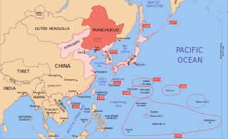
English: A map of the Manchukuo, 1939-09-01. Dates shown indicate the approximate year that Japan gain control of the possession. Japanese control of territory in China was tenuous. |
| Tanggal | |
| Sumber | |
| Juru pangarang |
|
| Vèrsi liya |
|


Kula, sing nduwèni hak cipta karya iki, mawa iki nerbitaké berkas iki sakisoré lisènsi kasebut:
Barkas iki kalilakaké sangisoring palilah Creative Commons Atribusi-Andum Mèmper 3.0 Tanpa Adhaptasi.
- Kowé kena:
- ngedum – nyalin, nyebar, lan ngirim karya
- nyampur – ngolah karya
- Sangisoré kahanan mangkéné:
- atribusi – Kowé kudu mènèhi krédhit kang patut, mènèhi pranala lisènsi, lan kandha yèn ana owah-owahan. Kowé bisa tumindak sasenengmu, nanging ora teges kang duwé lisènsi njurung lakumu.
- andum mèmper – Manawa kowé nyalin rupa, ngowahi, utawa nggawé karya nganggo bahan karya iki, kowé kudu mbabar karyamu kang wis dadi nganggo lisènsi kang padha utawa kang cocog karo karya asliné..

|
Idih kawènèhaké saprelu nyalin, ngedum, lan/utawa ngowah layang iki manut bebaku Palilah Pilayang Bébas GNU, Angka 1.2 utawa angka luwih anyar sing dibabar Yeyasan Piranti Alus Bébas; tanpa Pérangan Invarian, tanpa Tulisan Samak Arep, lan tanpa Tulisan Samak Buri. Salinan palilah dirembug ing pérangan asesirah Palilah Pilayang Bébas GNU. |
Kowé bisa milih lisènsi kang koarepaké.
Log unggah asli
This image is a derivative work of the following images:
- Image:Pacific_Area_-_The_Imperial_Powers_1939_-_Map.svg licensed with Cc-by-sa-3.0, GFDL
- 2008-08-08T01:16:33Z Emok 1039x814 (4678233 Bytes) {{Information |Description= |Source= |Date= |Author= |Permission= |other_versions= }}
- 2008-08-08T00:07:48Z Emok 1039x814 (4669659 Bytes) {{Information |Description= |Source= |Date= |Author= |Permission= |other_versions= }}
- 2008-08-07T05:03:23Z Emok 1039x814 (4669195 Bytes) {{Information |Description= |Source= |Date= |Author= |Permission= |other_versions= }}
- 2008-08-07T04:28:58Z Emok 1039x814 (4623405 Bytes) {{Information |Description= |Source= |Date= |Author= |Permission= |other_versions= }}
- 2008-08-07T04:02:57Z Emok 1039x814 (4602891 Bytes) {{Information |Description= |Source= |Date= |Author= |Permission= |other_versions= }}
- 2008-08-07T03:24:03Z Emok 1039x814 (4669511 Bytes) {{Information |Description= |Source= |Date= |Author= |Permission= |other_versions= }}
- 2008-08-04T16:59:39Z Emok 1039x814 (6442489 Bytes) {{Information |Description= |Source= |Date= |Author= |Permission= |other_versions= }}
- 2008-08-04T05:38:24Z Emok 1039x814 (6427678 Bytes) {{Information |Description= |Source= |Date= |Author= |Permission= |other_versions= }} [[Category:Imperialism]] [[Category:Oceania]]
- 2008-08-04T05:26:00Z Emok 104x82 (4765313 Bytes) {{Information |Description={{en|1=A map of the Imperial Powers of the Pacific, 1939-09-01. }} |Source=*[[:Image:World2Hires_filled_mercator.svg|]] |Date=2008-08-04 05:22 (UTC) |Author=*derivative work: ~~~ *[[:Image:World2Hir
Uploaded with derivativeFX
Sajarahing berkas
Klik ing tanggal/wektuné saprelu ndeleng rupané barkasé nalika tanggal iku.
| Tanggal/Wektu | Gambar cilik | Alang ujur | Naraguna | Tanggepan | |
|---|---|---|---|---|---|
| saiki | 16 Sèptèmber 2023 14.48 | | 634 × 387 (2,23 MB) | KajenCAT | File uploaded using svgtranslate tool (https://svgtranslate.toolforge.org/). Added translation for ca. |
| 2 Juni 2023 15.17 |  | 634 × 387 (2,2 MB) | SmallJarsWithGreenLabels | re-applying sp changes because this site sucks and gave me the old version of the svg for my second edit | |
| 1 Juni 2023 23.33 |  | 634 × 387 (2,2 MB) | SmallJarsWithGreenLabels | saipan per user:Geographyinitiative | |
| 1 Juni 2023 23.18 |  | 634 × 387 (2,19 MB) | SmallJarsWithGreenLabels | sp | |
| 27 Agustus 2010 01.37 |  | 634 × 387 (2,21 MB) | Splittist | No reason for Xinjiang to have separate borders from China | |
| 30 Mèi 2009 23.29 |  | 634 × 387 (2,21 MB) | SelfQ~commonswiki | Cluttering and removal of key elements is not acceptable. If you want a Chineese version please upload on under its own file name. | |
| 17 Mèi 2009 10.44 |  | 1.300 × 1.201 (864 KB) | Xiamipi | 增加中文说明 | |
| 21 Agustus 2008 02.52 |  | 634 × 387 (2,21 MB) | Emok | {{Information |Description= |Source= |Date= |Author= |Permission= |other_versions= }} | |
| 21 Agustus 2008 02.41 |  | 634 × 387 (2,21 MB) | Emok | {{Information |Description= |Source= |Date= |Author= |Permission= |other_versions= }} | |
| 8 Agustus 2008 01.41 |  | 634 × 387 (2,2 MB) | Emok | {{Information |Description= |Source= |Date= |Author= |Permission= |other_versions= }} |
Panggunaning berkas
Kaca ing ngisor iki nganggo barkas iki:
Panggunané barkas sajagat
Wiki liya ngisor iki nganggo barkas iki:
- Kanggo ing ar.wikipedia.org
- Kanggo ing azb.wikipedia.org
- Kanggo ing az.wikipedia.org
- Kanggo ing bg.wikipedia.org
- Kanggo ing bs.wikipedia.org
- Kanggo ing ca.wikipedia.org
- Kanggo ing da.wikipedia.org
- Kanggo ing el.wikipedia.org
- Kanggo ing en.wikipedia.org
- Kanggo ing fa.wikipedia.org
- Kanggo ing fr.wikipedia.org
- Kanggo ing hr.wikipedia.org
- Kanggo ing hy.wikipedia.org
- Kanggo ing id.wikipedia.org
- Kanggo ing it.wikipedia.org
- Kanggo ing ja.wikipedia.org
- Kanggo ing ja.wikibooks.org
- Kanggo ing lt.wikipedia.org
- Kanggo ing lv.wikipedia.org
- Kanggo ing mk.wikipedia.org
- Kanggo ing mn.wikipedia.org
- Kanggo ing ms.wikipedia.org
- Kanggo ing no.wikipedia.org
- Kanggo ing pt.wikipedia.org
- Kanggo ing sh.wikipedia.org
- Kanggo ing simple.wikipedia.org
- Kanggo ing sl.wikipedia.org
- Kanggo ing sr.wikipedia.org
- Kanggo ing ta.wikipedia.org
- Kanggo ing uk.wikipedia.org
- Kanggo ing uz.wikipedia.org